From various backups and by re-doing a chunk of work I’ve managed to get bustrackr.co.uk doing something useful again. It even does sensible things like caching now!
archive for the Technology category
A while back Lothian Buses fitted some fancy GPS tracking to all of their fleet enabling real-time tracking. Then LCD screens appeared at (selected) bus stops giving you a list of incoming buses and their ETA. All very clever. Then, at last they launched a web site which gave access to the same data: mybustracker.co.uk.
I think that making the website resemble the signs from the street is a poor design choice. Why not work with the medium you are presenting information over (the web) rather than trying to make it resemble something else? They constrain information into a tiny space, put it in a stupid font, make the background looks like all lcd-y, use excessive popups and it takes forever just to get to the basic information.
In shock news, this isn’t just a whiny post with no actual action. I present the beginnings of a “Bus Tracker API”. Think of it as a “cleaning” of the data for a fresh beginning. If we can get clean data out of the system then we can build a clean interface on top of it. My API is REST-ful and inspired by the flickr API. I have one method so far “bustracker.departures.getNext” which takes one parameter: the bus stop code. It shows you all of the incoming departures for a given bus stop. Here it is working for the stop nearest my flat. Feel free to change to bus stop code to another one by digging around the Bus Tracker website. I’ll hopefully have some other, more useful methods done soon and maybe some nifty google maps visuals…
Update: Source code now browsable at: http://code.google.com/p/bustrackr/
![]()
I can’t believe this hasn’t been more widely promoted but the Ordnance Survey is finally opening up it’s data for use on the internets. Their new Open Space project allows a Google Maps style interface to their (usually tightly restricted) mapping data. I do like the design of the OS maps, a nice alternative to Google. I’ve knocked up a quick demo centered on Edinburgh.
Animoto generates “shorts” compiled from your photos and set to music. They render lots of fancy effects, using your photos, apparently in time to the music. Pretty neat!
So apparently Matt and Tre have negotiated a deal where all past south park episodes are going to be streamable free online. Pretty damn shiny. Unfortunately this isn’t available in the UK yet and we can redirected to this hilarious page.
Some awesome guy has posted an episode of The Net online. The Net was a bbc show that started in 1994 that was sort of a Wired magazine on TV. It was way ahead of its time and had a brilliant “Net Cetera” feature at the end of every programme. This was where they would quickly flash screens full of information, URLS, telephone numbers etc that you were supposed to record and then play back in slow motion. Brings back memories…
I had a bit of a muck around with the Google Chart API last night. It’s very neat, you just make a request to google with your chart data and parameters all encoded in the get request, you get back a jpg image. I’ve used the API to generate a nice “spark line” graph of my blog posting frequency from July 2002 to the present. You can see it at the bottom of my index page.
This guy is a genius. His SMTP server has a customised welcome message which includes a URL to a page of disclaimers that override any of those stupid signature disclaimer messages.
Open Social, the future of social networks? Certainly looks promising.
So I all moved into my new place. The move was pretty painless, mainly thanks to the help of my Mum and Dad who came up for the weekend. My Dad drove a van we had hired and we got everything shifted fin two trips. Got my ADSL from Be activated within about four days and after some firmware updating shenanigans with the modem I’m all up and rocking. I did manage to trash my desktop PC in the moving process though, so I’m taking it as an excuse to upgrade to an uber-rig. I’m getting a dual core Pentium and 2 gigs of RAM (which is crazy cheap at the moment). Check out some quick snaps I took of my new place on flickr.
Mark, Al and myself are all in misty London for the Future of Web Apps conference which has been pretty good so far. Apart from the 4am wakeup and 6:30am flight from Edinburgh. We’ll see how long we last at the party tonight which has free adobe-sponsored beer…

Does it come in black?
Note: there are many different ways to to this. This is my personal approach.
Facebook provides RSS feeds for lots of things. One of these is the “Mini-feed” on your own profile. This can then further be filtered by “Status Stories” – this just being your own status updates in an RSS feed. Sounds promising…
Grab the URL for the RSS feed of this page. Now, we can’t just fopen() this URL in PHP as facebook are sneaky. They verify that the User-Agent is an actual browser or feed-reader. My approach was to use wget and it’s --user-agent parameter to pretend to be Internet Explorer. Dump the resulting XML somewhere and then parse out the inner HTML of the first <title> element. This is your current status. Easy.
A couple of weeks ago I attended the Scottish Society for Computers & Law annual lecture by Professor Eben Moglen entitled “The Global Software Industry in Transformation”. It was a very interesting lecture, mainly about the version of the “GNU General Public License” or GPL as it’s commonly shortened to. Eben is a computer scientist turned lawyer is a fantastically gripping speaker. Valley Technology (my employer) I am proud to say was a major sponsor and publicist for the event. Some of the guys I work with worked very hard recording audio and video from the event which is now up on archive.org to watch/listen to. I also took a couple of pictures which are on flickr.

My logo design for the Open Street Map conference “State Of The Map” has been chosen as the favourite entry from the sea of other submissions (two). Apparently it’s going to be on tshirts and everything, how exciting! Unfortunately I can’t make the conference but I’ve recently been getting very enthused about Open Street Map. A couple of weeks ago I saw an Edlug talk by Chris Fleming and was inspired enough to go out and buy a GPS device. I got a Holux 236 pretty cheaply off ebay.com. It’s a tiny wee unit that has no display, but can communicate through usb or over bluetooth. So, I can run a java app on my mobile that connects to the Holux and receives the data stream automagically. It all Just Works, most of the time. Here is a random route that I’ve run through GPS Visualizer to get some KML that is then plotted on our old friend Google Maps.
I have a laptop! A venerable IBM T23 with 512MB RAM clocked at a mighty 1133Mhz. I got it off ebay, something which lots of people have since said is usually a really, really bad idea. Apart from a crack on the back it does the job and is built like a tank. It came with an apparently legal install of Windows XP but I’ve installed ubuntu linux alongside it. So far I haven’t needed to boot into Windows for anything, all my hardware is supported in ubuntu. The install process was also incredibly smooth. You boot from a live CD and then the installer runs from inside the live CD version of linux. You can then muck around with the gnome default games (blackjack etc) whilst the installer is completing! I did have some strange issue with lilo not installing the first time, but I ran it again and it worked fine.
The PCMCIA wi-fi card that came with my laptop was pretty crappy and didn’t seem to be supported in linux. I shelled out a whole £10 for a new one that I knew was supported and it has been working fine. I also had to replace the battery as the charge only held for 20 mins, the seller freely admitted the battery wasn’t tested (ebay speak for broken) so it was to be expected. Ubuntu is the most user friendly linux distribution I’ve every installed. They obviously have actual people thinking about usability and being friendly to less experienced users. I’ve since ubuntu-orised my server box at home as well. It makes sense to just run one distribution.
Google have just released a really useful (geeky) addition to the already excellent Google Maps. My Maps allows you to easily create custom maps with your own markers, points, polygons and notes placed wherever you want them. All of this was possible in the past but either required hacking about with Javascript or use of some third party tool. Here is a map I quickly knocked up to show my current and new work-places in relation to home. More help on creating your own maps is available in the Maps help section.
Well, the Highland Fling is over!
It was a great day with very interesting speakers covering a great range subjects but centred around Web Standards and “Progressive Enhancement”. Progressive Enhancement (as I understood it) is the opposite to “Graceful Degradation”. If you plan your project with the bling included and then go back and undo the bling to provide functionality to less advantaged users (Graceful Degradation) then 9 times out of 10 you won’t get the time/money to actually undo the bling. If, on the other hand you plan your project so that you get the core functionality working across the board and then add the bling, you’re much more likely to finish with a system accessible to all. This was the message I got from Norm from Yahoo’s talk. It’s a shame he had such a bad throat, he could barely talk!
Some other good speakers were:
The intro by Jeremy Keith – an excellent speaker and drew lots of parallels with literature such as Pattern Recogniton and Neuromancer. Props!
Andy Budd’s talk on the future of CSS was exciting but about the only thing widely supported in CSS3 currently seems to be the opacity elememt. Other interesting elements that will be supported eventually are border-radius for rounded corners and box-shadow for drop shadows. The Advanced Layout module looks like it will blow the current css layout methods out of the water with it’s grid system for layout and re-ordering of the content. Slightly dis-heartening was Andy’s complaints about the workings of the CSS Working Group: the snail-like pace it operates and the possible influence of Big Business on it’s decisions.
Drew McLellan’s talk on Microformats was a bit dry but still good to see them getting pimped.
James Edwards came across as the Grumpy Man of Web Standards with a talk about when to use Ajax (never, if he had his way). He had a point though, and hopefully people will take notice and not just do Ajax for the sake of it.
Andy Clarke ended the day with a nice chatty presentation about what exactly “Progressive” enhancement is, relating it to progressive in the music world. Some interesting anecdotes from the world of freelance designers including a snippet from this standard contract that explicitly lists the browsers a site will be compatible. Also very nicely designed slides, as you’d expect really. Andy also sits on the CSS Working Group as some kind of invited member, he talked of his frustrations with the slow process but also made good points that the working group has to consider not just CSS used for screen rendering and the can of worms that internationalisation is.
There are people I’ve missed and lots of stuff I’ve forgotten already but there are lots of others writing about the Fling. Where do I sign up for next year?
So I’m just about to write a post about how gravatar.com was down for ages and now seems to be back. But, their site is current giving me a 503 error. Super. Gravatar was great for a bit but then became incredibly slow, obviously because of the increased popularity, then just stopped working completely for a while. Looks like they aren’t out of the woods yet. They should go talk to Matt and co. over at Automattic.
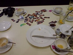
I went along to my first Edinburgh Coffee Morning today at a startlingly early 8am. Met up with Nico on the way who was cycling to work, I should really start doing that. Anyway, the coffee chat was excellent. Talked to lots of different people: designers, developers, teachers, advertisers. It’s an eclectic mix of folks and makes for a good range of topics, generally about web “2.0” (god I’m sick of that term). Let’s see who I can remember: Johnnie Walker, Mike, Ewan, Phil and lots of other people who’s names I can’t remember. I’ll definitely try and make it next week.
Web events seem to be sprouting up all of the place at the minute in Edinburgh! I’m attending the Highland Fling conference in April which sounds very interesting. Refresh Edinburgh has also appeared out of the wood-work to hold an event on the day after Highland Fling. Plus, there is Barcamp Scotland happening in March, based in Appleton Tower no less. Interesting times.
Update: Also Web Security Conference Day for Windows Developers from scottishdevelopers.com, thanks John.
Very clever video with a good message:
Sex offenders could be forced to register their e-mail addresses and chatroom names, the government says.
This has got to be the stupidest idea I’ve heard for a while and a prime example of the illusion of security as often explained by Bruce Schneier. In real life it is tricky but not impossible to fake an identity. But online a new “identity” (email address or chat nickname) can be created in seconds. Plus, what is this supposed system that would be screen all of these people? How soon would that system’s powers be abused for “law enforcement” purposes or the database get leaked/stolen? There are some real technological geniuses manning the pumps somewhere in our government…
I’ve ditched my oh-so-2006 binary feed reader and switched to Google Reader. It’s pretty slick to use and has clever stats and features that just aren’t present in desktop application readers. I can also catch up on all my feeds in my lunch break at work or just generally when I’m not at my home PC.
I was talking with my Mum last night and realised that we share one (among many) particular trait: not finishing things. In my free time I’m great at starting projects but not so good at actually finishing them. So, with that in mind I’m listing all of my half finished projects here in a hope of shaming myself into maybe finishing them off some day.
Lothian buses routes on Google Maps
Take the route (list of street names) from the Lothian Buses timetable and dump them into the Google Maps route finder. Inelegantly scape the results to extract the GPolygon munge. Then stick all the paths together to get the final route.
Shown left is the (rough) route of the number 22. The bus I used to have to take to work when I lived out in the “boonies”.
WordPress Amazon plugin

I’ve started a WordPress plugin to allow easy access to the Amazon e-commerce API. Mainly to facilitate extracting product information. So you can say stuff like “I’m currently reading –AMAZONASIN–” and my plugin will fetch all the necessary information like title, author, image etc. The API isn’t super-fast so I’m currently at the stage of working out a schema to cache all the necessary information. The different types of products all have a different subset of attribute fields, so I’m trying to work out a flexible solution. I’ve also worked on some image processing trickery to allow for the oh so trendy apple-style “book at angle with reflection” image (as seen left). It’s a bit jaggy at the minute, I need to find out how to do blurring with GD in PHP. I’ve even got a Google Code page for this project which handily has SVN access.
I know there are a few plugins out there that do this already but they either aren’t flexible enough or just look too amateurish for my liking.
Edinburgh Urban Art
I started doing an interface to the Flickr group I set up. The basics are there but it could do with some more pizazz.
Book Blog
Over at /books/ I like to keep track of what I’ve been reading. I’ve managed to keep this up for almost two years but should really get around to doing something more exciting with the design. Actual book data is what inspired my WordPress plugin above. So, when that is finished the page should be awash with tags, photos, reviews etc.
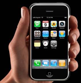
No doubt I’m adding to the general blog buzz here about the latest Apple announcement but it’s just too shiny to pass up. Yes, it is called the iPhone even though Linksys own the name (or whatever that last rumour was). It’s a combination of the “wide screen video iPod” and the “apple mobile” rumours. I have to say, I want one.
In real terms, they are far too expensive, will probably scratch easily and aren’t out in Europe until the end of the year. Still shiny though…
This week I received a useful cold call. It started with the usual mobile phone stuff and I was about to hang-up when the dude mentioned that my contract was about to run out, whoah, could actually be a legit call. It was, my contract had run out (I had no idea) and was apparently in “rolling” mode. So they tempted me to stay on with a free upgrade and an attempt at selling me a vastly over-priced plan and some phone insurance. I took the free K800, thank you very much. It’s a very shiny phone with an awesome screen, plus it was in Casino Royale. Check out the evolution with my last three phones:
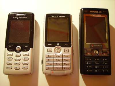
Left to right: T610, K750 & K800.
Screens are getting bigger (and higher resolution) and keypads are getting more cluttered. The ‘start’ and ‘end’ call buttons on the K800 are pretty tiny, squeezed in at the side like that. The K800 seems a bit more ‘bling’ than the others and more nokia-ish. Other nice improvements are more tactile keys, a better camera, a real flash, autofocus, image stabilisation, an RSS reader and a blogging tool! The latter seems to only support blogger, which is a shame. We’ll see how this new phone lasts.
Via Tech Crunch UK I’ve started using a new web service called Stikkit. It’s basically just online post-it notes, very similar to the Stickies application in OS X. I’ve been wanting something like this for a while, google do calendars and mail very well, there are todo lists from 37signals but no generic note taking application. Stikkit is quite clever, as you’re writing a note it tries to calculate whether it is a todo list or an event, depending on the wording you use. So, writing “Buy beer for party on Friday at 8pm” automatically creates a event with the correct date and time. One immediate use I see for this is to quickly add things to google calendar. Just add your events through Stikkit and then show the event RSS feed on your google calendar. Creating “stikkits” is made super easy with a nifty bookmarklet that opens a wee AJAX powered window on your current webpage for data entry.
There are a lot more nifty feature but John “Markdown” Gruber has a very good review on his blog. I’d agree with him about the icons, I really didn’t know what most were going to do when I pressed them.
As reported on the Google Maps API blog they’ve vastly improved the speed of the addOverlay() function. My bbc travel warnings mashup loading time has greatly improved. Nice one google.
The (almost) final list of CSS bug fixes in IE 7. Hopefully the take-up of IE7 will be such that we can now just develop for gecko and IE7 based browsers.
I made my first purchase from Warp’s super cool DRM free music download site bleep.com this week. It was cheap, easy and gave me a plain old mp3 out at the end. The way iTunes should be…
Great new updates to the Google Maps API that allow draggable markers and tiled overlays. The draggable markers even “bounce” back on to the map when you drop them, very slick.
I don’t blame them, and it’s pretty funny. Mainly becuase it will rile microsoft so much 🙂
“Google says Microsoft is unfairly grabbing Web traffic by making its MSN search engine the default in its browser.”
From the New York Times.
I honestly do not know how Google thinks it’s view point is in anyway unbiased in this argument. People need to stop thinking of them as this cutsy dot com company and notice the all encompassing cash juggernaut they’ve become.
Wow! That is a lot of data and it’s presented reasonably nicely for a prototype. Although, does every web app have to looks like a Ruby on Rails test installation?
So, I broke the other day and started using iTunes about 3 months after getting my Nano. It is actually not such a bad programme and hasn’t quite taken over my music collection in the evil-hell-spawn way I thought it might. What lead me to use iTunes was the fact that I totally broke my Nano messing around with ipodlinux. I had to do an ipod restore and it was just easier to use iTunes…damn Apple and their bundled easy to use feature packed software. Whilst exploring the iTunes interface I came across the vast index of podcasts that Apple let you browse through. I’m now hooked on radio five’s film review podcast, and one from “Security Now” is also quite interesting. It’s like radio for your ipod that you can pause! Great stuff.
So, about 6 months after I realised I needed to upgrade my PC I’ve finally done it!
I now have a shiny AMD Sempron 3100+ on a Gigabyte K8NS-PRO with a Gig of Crucial RAM. This also means I now have the mighty increased speed of USB 2.0, SATA drives, Firewire and lots of other things that my old motherboard didn’t support. Needless to say, pretty much everything runs a heck of a lot quicker.
This whole hardware thing had moved on a bit since I last put a PC together (man, that makes me sound old). The motherboard has a nice plastic guide thing for the heatsink and it all clips in very neatly and easily. No jamming a screwdriver into fiddly bits of metal and forcing clips onto tiny bits of plastic. This motherboard has something daft like 3 RAID controllers, onboard sound, LAN, kitchen sink etc which makes the BIOS setup screen an absolute mess of options – the only downside to all this increased complexity. So far though, everything has run very smoothly and my CPU temperature when under load has dropped to around 30°C (from 60°C plus).
With my hard earned xmas bonus I’ve splashed out on a new digital camera, a Pentax Optio 60.
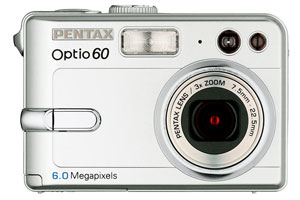
It’s a 6 mega-pixel thing with oodles more features than my old skool Fuji 2800. I will miss the mighty 6x optical zoom but I absolutely will not miss the size of the flippin’ thing. It was huge. Get ready for an influx of pictures when my new one arrives.
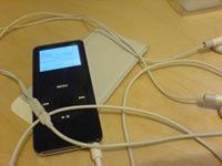

Uh-oh, I think I might own an ipod. Not sure how that one happened… It might have something to do with mentioning to my parents that I would like one for Christmas. It is unbelieveably shiny and so small!
I opted for a (ninja) black 4 Gb Nano, mainly for the ease of carrying and for a decent amount of space. I don’t really want to carry around my whole music collection, but then I don’t want to have to rotate albums every day or something (like with a shuffle). As a Windows user I’m allergic to iTunes so I ditched that at the earliest convenience and I’m using mlipod for winamp which is aces-cool.
The screen is great and the scroll wheel is easy to use once you get the hang of it. The UI is the usual Apple slickness and makes navigating around really easy. I haven’t tried any video on it, but the photo album is vaguely useful and has pretty slideshows. It’s usability is limited on a screen so small though. The whole Nano is incredibly easy to scratch, I have a few minor ones after only a week so I’ve ordered a case for it which should help a bit.
More on my adventures in Apple-land in time.
So, the big Y! makes yet another social-software purchase and buys del.icio.us. I started using delicious last year and while I didn’t find the whole book marking thing that useful I do try to trawl delicious popular once a day to catch up on all the latest trends. It seem that Yahoo! is taking taking a different approach to the big G. Google tend to hire the super-academics and take the “look how smart we are” approach. Whilst Yahoo! are hiring (and buying) the entrepreneurs to broaden their portfolio of online services to provide to Yahoo! users, “look how friendly we are”.
It’s quite a turn around as Google used to be the friendly new kid on the block, with Yahoo the bumbling, messy old guy trying to keep up. Now everyone is realising that Google is not infallible, is making billions of dollars a year, has endless beta cycles and generally wants to index every bit of data, ever. Yahoo are trying to get close to the people who use their products, they’ve finally got into blogging, launched a nicer API than Google and started buying up the social apps that people actually use (upcoming, flickr, delicious etc). I still like Google’s products, Maps is just awesome, but somehow I feel they’ve become more corporatey than Yahoo!
So I bought Ian’s old PC case of him as a replacement for my monstrous tower. “old” in Ian terms is, like, more than 6 months so it’s still pretty spiffy. It’s made from super light aluminium and has a very shiny black automative paint finish. Rather hilariously, as I was trying to take a picture of it to post here my camera fell off my desk with the lense extended…ouch. It’s now at a rather wonky angle and won’t zoom in and out, officialy “shonky”. Oh well, it is more than three years old and probably only worth about £50 (its got quite a bit of previous battle damage). Looks like I’ll be picking up a new one in the January sales.
Update: Just remembered. When I had got everything moved into the new case I fired it up and got a continuous high-pitched beep. Strange….because this case doesn’t even have a speaker! I finally realised that I hadn’t plugged the molex power connector into my uber geforce 6800 graphics card. That did the trick, the card itself must have a speaker to warn you of low power or something.
The BBC has been keeping a vast catalogue of information about all the programmes it has put out for more that fifty years. It has been maintained all this time by a “crack team of librarians” and has so far been for internal BBC use only. Now, with the help of the BBC Backstage project (use our stuff to build your stuff) it could soon be useable for anyone on the ‘net and hopefully hackable for all of us geeks. Matt Biddulph is working on this for the BBC and gives us a sneak peek. Take a look at some of his screenshots, the breadth and detail of the information is vast.
I’ve just realised that I haven’t blogged about the free blueyonder speed increases. I was originally on a pretty standard 1Mb cable line, but now have a mighty 4Mb! This is mainly the cable companies playing catch-up with ADSL and completely out-doing them so they don’t get left too far behind. This new connection means I can download at 500kb/s (that’s kilo-bytes!) and upload at 48kb/s. Awesome 🙂
So now that I have my shiny new wireless access point I’ve managed to get my media player thing working over wirelss. Which is just beyond cool and keeps Kerry happy, as there aren’t huge lengths of CAT-5 trailed eveywhere. Its a nice little box and fits in with the rest of the D-Link range. I’ve had no problems so far with reception but then it’s only going about five metres. The firmware is pretty neat and has stuff like syslogd support so that the access point log gets piped across to my linux box’s logs aswell. Now I just need a laptop or something to waft around the flat, marvelling at the magical wireless technology.
We’re often joking at work about how cold it is. Maybe this is the answer: The Heated Mouse.
Now that we’ve got a TV and everything in an actual living room the problem arose of how to watch all of our downloaded media on it. Kerry would have probably killed me if I’d set-up a noisy media PC in there, plus it would be a bit too expensive. A chipped xbox was another option, or some kind of dedicated divx player. I was browsing ebuyer and came across the Lite-On LVD-2010 which is a DVD player than can also play mpg4, divx etc and can stream stuff via ethernet. Seems pretty sweet! I faffed around too long though and ebuyer sold out, I eventually got one from dvdplayers.co.uk, who have now sold out aswell.
It’s a neat bit of kit. It looks just like a normal DVD player but can play content from a ‘Media Server’ on the local network. This clever ‘Media Server’ is actually just a web server that offers a file browsing interface and streams the files to the box. The server software that comes in the box is pants, and uses Java (eww). SwissCenter is a much nicer, open source project that just uses a mini version of apache and PHP. The only problems so far have been that it can’t play q-pixel encoded divx files (whatever the heck they are) and it doesn’t support movie subtitles in external files.
In the retail box you also get a wireless bridge adaptor so that you don’t need to run CAT-5 to the box. I haven’t yet got this working, mainly because I don’t have a wireless access point for it to work with. This presented an excellent opporunity to get one though, and I shelled out for a D-Link DWL-2000AP+ which should arrive tomorrow. More toys! 🙂

I know I’m becoming a total mac-geek when I like t-shirts with mac GUI widgets on them. At work I use a mac while at home I’m in PC/Windows land. I have to say, there are more elements of OS X that I’d like in Windows rather than vice-versa.
The shopping cart system over on panic.com is also awesomely cool and the UI is instantly useable to mac users.
There’s a great article over on rollingstone.com about Justin Frankel, the guy behing winamp, the AOL buy-out of his company and the ensuing fallout. I remember the very first time I ran winamp on a PC, it was and still is a very nice piece of software.